Tahquitz Peak via South Ridge Trail in San Jacinto Wilderness
The South Ridge Trail to Tahquitz Peak offers hikers an invigorating ascent through a dense pine and oak forest, with expansive views of Idyllwild, Suicide Rock, and Lily Rock emerging as you climb. As you gain elevation, the trail opens up to breathtaking vistas of the San Jacinto Mountains, offering glimpses of distant peaks like Mount Baldy and sweeping views of nearby valleys. The final stretch to the summit, with its series of switchbacks, brings you to a historic fire lookout with panoramic views of the surrounding wilderness, making this strenuous yet rewarding hike a memorable experience. #Hiking #Mountain #Forest #Overlook #Nature
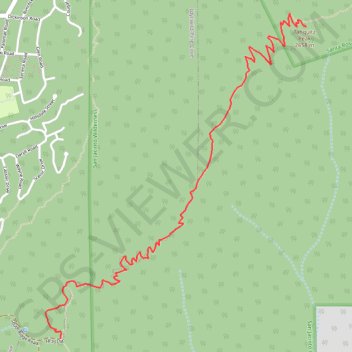
- Distance: 6.6 mi
- Elevation gain: 2,290 ft
- Maximum elevation: 8,750 ft
- Elevation loss: 2,280 ft
- Minimum elevation: 6,512 ft
Interactive trail map
Trail profile
- Distance: 6.6 mi
- Elevation gain: 2,290 ft
- Maximum elevation: 8,750 ft
- Elevation loss: 2,280 ft
- Minimum elevation: 6,512 ft
About this trail
Name: Tahquitz Peak via South Ridge Trail in San Jacinto Wilderness trail, distance, elevation, map, profile, GPS track
Start: Lower South Ridge Trail, Riverside County, California, 92599, United States (33.73535 -116.69595)
End: South Ridge Trail, Riverside County, California, 92599, United States (33.73562 -116.69594)
Coordinates: 33.73535 -116.69711 33.75621 -116.67705
Topography: Riverside County topographic map, elevation, terrain
Other hiking, mountain biking, running and outdoor activity trails
Click on a trail to view its statistics, map and profile.
Ernie Maxwell Scenic Trail
United States > California > Riverside County > Idyllwild
Starting from the Idyllwild side near Tahquitz View Drive, the Ernie Maxwell Scenic Trail climbs gently through shaded pine, oak, cedar and manzanita forest on the lower slopes of the San Jacinto Mountains. The route passes granite boulders and seasonal drainages before opening occasional views across…
Distance: 2.3 mi • Elevation gain: 935 ft • Maximum elevation: 6,450 ft
Pacific Crest Trail (PCT) through San Bernardino Forest and Santa Rosa and San Jacinto Mountains
United States > California > Riverside County
Hike from Bull Canyon Parking to Snow Creek along the Pacific Crest National Scenic Trail via Lion Peak, Pyramid Peak, Cedar Spring, Palm View Peak, Fobes Saddle, Spitler Peak, Apache Peak, Apache Spring, Antsell Rock, South Peak, Red Tahquitz, Tahquitz Meadow, Powderbox Spring, Middle Spring, Jolley Spring,…
Distance: 59.0 mi • Elevation gain: 13,064 ft • Maximum elevation: 8,980 ft
Suicide Rock
United States > California > Riverside County > Idyllwild
Hike to Suicide Rock by the Deer Springs Trail and the Suicide Rock Trail in the San Bernardino National Forest and the Mount San Jacinto State Wilderness. #Hiking #Mountain #Nature #Forest #Wilderness
Distance: 3.4 mi • Elevation gain: 1,864 ft • Maximum elevation: 7,431 ft
Mount Jacinto Loop
United States > California > Riverside County > Idyllwild
Loop Hike to Mount Jacinto via Deer Springs Trail, Pacific Crest Trail (PCT), Peak Trail and Wellman's Cienaga Trail in the San Bernardino National Forest and the Mount San Jacinto State Park. #Hiking #Loop #Mountain #Nature #Forest #Park #PCT
Distance: 17.4 mi • Elevation gain: 5,400 ft • Maximum elevation: 10,758 ft
Suicide Rock
United States > California > Riverside County > Idyllwild
Hike from Idyllwild Nature Center to Suicide Rock via Deer Springs Trail and Suicide Rock Trail in the San Bernardino National Forest and the Mount San Jacinto State Wilderness. #Hiking #Mountain #Nature #Forest #Wilderness
Distance: 7.5 mi • Elevation gain: 2,093 ft • Maximum elevation: 7,421 ft
Ernie Maxwell Trail
United States > California > Riverside County > Idyllwild
Riverside County Hiking
Distance: 4.9 mi • Elevation gain: 1,161 ft • Maximum elevation: 6,447 ft