Carriage Room Museum Loop via Alambique Trail, Meadow Trail, Madrone Trail and Bear Gulch Trail
The Carriage Room Museum Loop at Wunderlich County Park offers a delightful blend of history and natural beauty. The trail leads hikers through lush redwood groves, oak woodlands, and open meadows, providing scenic vistas of the San Francisco Peninsula. Along the route, visitors can enjoy the tranquility of shaded gulches, occasional panoramic views, and the charm of the historic Carriage Room Museum, set at the start of the hike. #Hiking #Loop #Mountain #Forest #Overlook #Nature
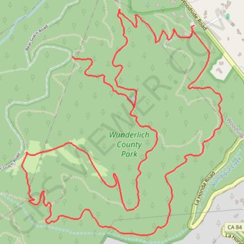
- Distance: 7.2 mi
- Elevation gain: 1,811 ft
- Maximum elevation: 1,444 ft
- Elevation loss: 1,798 ft
- Minimum elevation: 486 ft
Interactive trail map
Trail profile
- Distance: 7.2 mi
- Elevation gain: 1,811 ft
- Maximum elevation: 1,444 ft
- Elevation loss: 1,798 ft
- Minimum elevation: 486 ft
About this trail
Name: Carriage Room Museum Loop via Alambique Trail, Meadow Trail, Madrone Trail and Bear Gulch Trail trail, distance, elevation, map, profile, GPS track
Start: Bear Gulch Trail, Woodside, San Mateo County, California, 94062, United States (37.41096 -122.26110)
End: Bear Gulch Trail, Woodside, San Mateo County, California, 94062, United States (37.41062 -122.26124)
Coordinates: 37.39766 -122.27484 37.41199 -122.25887
Topography: San Mateo County topographic map, elevation, terrain