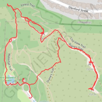
Hahn Park North End
- Distance: 1.4 mi
- Elevation gain: 312 ft
- Maximum elevation: 482 ft
- Elevation loss: 308 ft
- Minimum elevation: 272 ft
- Moving time: 44 m 48 s
- Moving speed: 1.8 mph
- Maximum speed: 5.6 mph
- Total time: 1 h 32 m
- Global speed: 0.9 mph
Interactive trail map
Trail profile
About this trail
Name: Hahn Park North End trail, distance, elevation, map, profile, GPS track
Start: Park to Playa Trail, Los Angeles County, California, 90230, United States (34.01316 -118.37165)
End: Waterfall Trail, Los Angeles County, California, 90230, United States (34.01374 -118.37194)
Coordinates: 34.01315 -118.37268 34.01645 -118.36876
Topography: Los Angeles County topographic map, elevation, terrain