Conwy Trail Running
Bryn
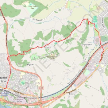
- Distance: 4.0 mi
- Elevation gain: 407 ft
- Maximum elevation: 341 ft
- Elevation loss: 394 ft
- Minimum elevation: 7 ft
- Moving time: 48 m 36 s
- Moving speed: 4.9 mph
- Maximum speed: 8.9 mph
- Total time: 55 m 42 s
- Global speed: 4.3 mph
Interactive trail map
Trail profile
- Distance: 4.0 mi
- Elevation gain: 407 ft
- Maximum elevation: 341 ft
- Elevation loss: 394 ft
- Minimum elevation: 7 ft
- Moving time: 48 m 36 s
- Moving speed: 4.9 mph
- Maximum speed: 8.9 mph
- Total time: 55 m 42 s
- Global speed: 4.3 mph
About this trail
Name: Conwy Trail Running trail, distance, elevation, map, profile, GPS track
Start: Conway Road, Llandudno Junction, Conwy, Wales, LL31 9LN, United Kingdom (53.28431 -3.80887)
End: Bryn Marl Road, Mochdre, Conwy, Wales, LL28 5DY, United Kingdom (53.29212 -3.76236)
Coordinates: 53.28431 -3.80887 53.30473 -3.76002