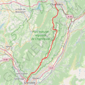
Chartreuse-16619139
- Distance: 43.4 mi
- Elevation gain: 14,774 ft
- Maximum elevation: 6,745 ft
- Elevation loss: 14,593 ft
- Minimum elevation: 702 ft
- Moving time: 13 h 45 m
- Moving speed: 3.2 mph
- Maximum speed: 8.0 mph
- Total time: 13 h 45 m
- Global speed: 3.2 mph
Interactive trail map
Trail profile
- Distance: 43.4 mi
- Elevation gain: 14,774 ft
- Maximum elevation: 6,745 ft
- Elevation loss: 14,593 ft
- Minimum elevation: 702 ft
- Moving time: 13 h 45 m
- Moving speed: 3.2 mph
- Maximum speed: 8.0 mph
- Total time: 13 h 45 m
- Global speed: 3.2 mph
About this trail
Name: Chartreuse-16619139 trail, distance, elevation, map, profile, GPS track
Coordinates: 45.19132 5.71468 45.57143 5.93540
Other hiking, mountain biking, running and outdoor activity trails
Click on a trail to view its statistics, map and profile.
PT23DS2 Lörrach → Cadaqués
Germany > Baden-Württemberg > Landkreis Lörrach > Lörrach (Kernstadt)
Distance: 652.9 mi • Elevation gain: 43,077 ft • Maximum elevation: 4,938 ft
Chemin de Saint-Jacques-de-Compostelle
Switzerland > Geneva > Geneva
Distance: 694.6 mi • Elevation gain: 82,881 ft • Maximum elevation: 4,692 ft