Lions Club Park to Franklin Mills Riveredge Park via Freedom Trail and Portage Hike & Bike Trail
- Distance: 11.6 mi
- Elevation gain: 453 ft
- Maximum elevation: 1,148 ft
- Elevation loss: 433 ft
- Minimum elevation: 1,007 ft
- Moving time: 1 h 30 m
- Moving speed: 7.7 mph
- Maximum speed: 12.1 mph
- Total time: 1 h 58 m
- Global speed: 5.9 mph
Interactive trail map
Trail profile
- Distance: 11.6 mi
- Elevation gain: 453 ft
- Maximum elevation: 1,148 ft
- Elevation loss: 433 ft
- Minimum elevation: 1,007 ft
- Moving time: 1 h 30 m
- Moving speed: 7.7 mph
- Maximum speed: 12.1 mph
- Total time: 1 h 58 m
- Global speed: 5.9 mph
About this trail
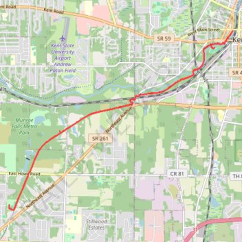
Name: Lions Club Park to Franklin Mills Riveredge Park via Freedom Trail and Portage Hike & Bike Trail trail, distance, elevation, map, profile, GPS track
End: East Garwood Drive, Tallmadge, Summit County, Ohio, 44278, United States (41.11050 -81.43332)
Coordinates: 41.10910 -81.43346 41.15336 -81.36017
Topography: Summit County topographic map, elevation, terrain
Other hiking, mountain biking, running and outdoor activity trails
Click on a trail to view its statistics, map and profile.
Park Lake
United States > Ohio > Summit County > Munroe Falls
Distance: 1.1 mi • Elevation gain: 69 ft • Maximum elevation: 1,083 ft