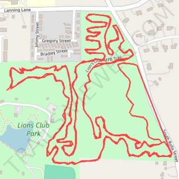
Lions Club MTB Trail Loop x2
- Distance: 7.1 mi
- Elevation gain: 295 ft
- Maximum elevation: 1,155 ft
- Elevation loss: 292 ft
- Minimum elevation: 1,076 ft
- Moving time: 50 m 29 s
- Moving speed: 8.4 mph
- Maximum speed: 20.8 mph
- Total time: 50 m 29 s
- Global speed: 8.4 mph
Interactive trail map
Trail profile
- Distance: 7.1 mi
- Elevation gain: 295 ft
- Maximum elevation: 1,155 ft
- Elevation loss: 292 ft
- Minimum elevation: 1,076 ft
- Moving time: 50 m 29 s
- Moving speed: 8.4 mph
- Maximum speed: 20.8 mph
- Total time: 50 m 29 s
- Global speed: 8.4 mph
About this trail
Name: Lions Club MTB Trail Loop x2 trail, distance, elevation, map, profile, GPS track
Start: Lion's Club MTB Trail, Rolla, Phelps County, Missouri, 65401, United States (37.92859 -91.77474)
End: Lion's Club MTB Trail, Rolla, Phelps County, Missouri, 65401, United States (37.92864 -91.77453)
Coordinates: 37.92591 -91.77474 37.93134 -91.76717
Topography: Rolla topographic map, elevation, terrain