Thank you for supporting this site ❤️
Make a donation
Make a donation
Gear up for your next adventure:
As an Amazon Associate, this site earns from qualifying purchases at no extra cost to you.
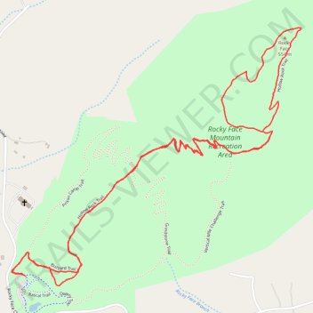
Rocky Face Mountain via Hollow Rock Trail
- Distance: 3.4 mi
- Elevation gain: 650 ft
- Maximum elevation: 1,765 ft
- Elevation loss: 650 ft
- Minimum elevation: 1,145 ft
- Moving time: 47 m 36 s
- Moving speed: 4.3 mph
- Maximum speed: 6.7 mph
- Total time: 47 m 36 s
- Global speed: 4.3 mph
Interactive trail map
Thank you for supporting this site ❤️
Make a donation
Make a donation
Gear up for your next adventure:
As an Amazon Associate, this site earns from qualifying purchases at no extra cost to you.
Trail profile
- Distance: 3.4 mi
- Elevation gain: 650 ft
- Maximum elevation: 1,765 ft
- Elevation loss: 650 ft
- Minimum elevation: 1,145 ft
- Moving time: 47 m 36 s
- Moving speed: 4.3 mph
- Maximum speed: 6.7 mph
- Total time: 47 m 36 s
- Global speed: 4.3 mph
Thank you for supporting this site ❤️
Make a donation
Make a donation
Gear up for your next adventure:
As an Amazon Associate, this site earns from qualifying purchases at no extra cost to you.
About this trail
Name: Rocky Face Mountain via Hollow Rock Trail trail, distance, elevation, map, profile, GPS track
Start: Quarry Trail, Alexander County, North Carolina, United States (35.96366 -81.12035)
End: Quarry Trail, Alexander County, North Carolina, United States (35.96366 -81.12036)
Coordinates: 35.96332 -81.12097 35.97271 -81.10794
Topography: Alexander County topographic map, elevation, terrain
Thank you for supporting this site ❤️
Make a donation
Make a donation
Gear up for your next adventure:
As an Amazon Associate, this site earns from qualifying purchases at no extra cost to you.