Make a donation
Gear up for your next adventure:
As an Amazon Associate, this site earns from qualifying purchases at no extra cost to you.
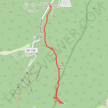
Spring Mountains - Pioneer Rock and Foxtail Spring
- Distance: 4.1 mi
- Elevation gain: 1,352 ft
- Maximum elevation: 9,659 ft
- Elevation loss: 1,352 ft
- Minimum elevation: 8,307 ft
- Moving time: 1 h 55 m
- Moving speed: 2.1 mph
- Maximum speed: 3.8 mph
- Total time: 2 h 7 m
- Global speed: 1.9 mph
Interactive trail map
Make a donation
Gear up for your next adventure:
As an Amazon Associate, this site earns from qualifying purchases at no extra cost to you.
Trail profile
- Distance: 4.1 mi
- Elevation gain: 1,352 ft
- Maximum elevation: 9,659 ft
- Elevation loss: 1,352 ft
- Minimum elevation: 8,307 ft
- Moving time: 1 h 55 m
- Moving speed: 2.1 mph
- Maximum speed: 3.8 mph
- Total time: 2 h 7 m
- Global speed: 1.9 mph
Make a donation
Gear up for your next adventure:
As an Amazon Associate, this site earns from qualifying purchases at no extra cost to you.
About this trail
Name: Spring Mountains - Pioneer Rock and Foxtail Spring trail, distance, elevation, map, profile, GPS track
Start: Lee Canyon Road, Lee Canyon, Clark County, Nevada, United States (36.32011 -115.67213)
End: Lee Canyon Road, Lee Canyon, Clark County, Nevada, United States (36.32003 -115.67218)
Coordinates: 36.29542 -115.67410 36.32011 -115.66820
Topography: Clark County topographic map, elevation, terrain
Make a donation
Gear up for your next adventure:
As an Amazon Associate, this site earns from qualifying purchases at no extra cost to you.
Other hiking, mountain biking, running and outdoor activity trails
Click on a trail to view its statistics, map and profile.
Lee Ski Resort Hiking Trail
United States > Nevada > Clark County
Distance: 4.3 mi • Elevation gain: 948 ft • Maximum elevation: 9,327 ft