Thank you for supporting this site ❤️
Make a donation
Make a donation
Gear up for your next adventure:
As an Amazon Associate, this site earns from qualifying purchases at no extra cost to you.
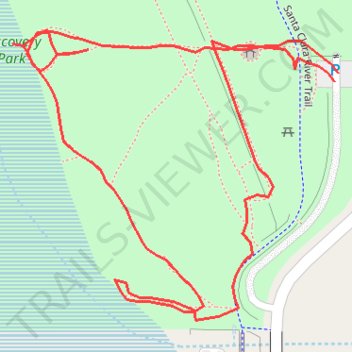
Discovery Park
- Distance: 0.5 mi
- Elevation gain: 13 ft
- Maximum elevation: 1,335 ft
- Elevation loss: 13 ft
- Minimum elevation: 1,322 ft
- Moving time: 18 m 23 s
- Moving speed: 1.7 mph
- Maximum speed: 3.7 mph
- Total time: 20 m 45 s
- Global speed: 1.5 mph
Interactive trail map
Thank you for supporting this site ❤️
Make a donation
Make a donation
Gear up for your next adventure:
As an Amazon Associate, this site earns from qualifying purchases at no extra cost to you.
Trail profile
- Distance: 0.5 mi
- Elevation gain: 13 ft
- Maximum elevation: 1,335 ft
- Elevation loss: 13 ft
- Minimum elevation: 1,322 ft
- Moving time: 18 m 23 s
- Moving speed: 1.7 mph
- Maximum speed: 3.7 mph
- Total time: 20 m 45 s
- Global speed: 1.5 mph
Thank you for supporting this site ❤️
Make a donation
Make a donation
Gear up for your next adventure:
As an Amazon Associate, this site earns from qualifying purchases at no extra cost to you.
About this trail
Name: Discovery Park trail, distance, elevation, map, profile, GPS track
Coordinates: 34.42357 -118.48284 34.42493 -118.48099
Topography: Santa Clarita topographic map, elevation, terrain
Thank you for supporting this site ❤️
Make a donation
Make a donation
Gear up for your next adventure:
As an Amazon Associate, this site earns from qualifying purchases at no extra cost to you.
Other hiking, mountain biking, running and outdoor activity trails
Click on a trail to view its statistics, map and profile.
Discovery Park Loop Walk
United States > California > Los Angeles County > Santa Clarita
Distance: 0.9 mi • Elevation gain: 23 ft • Maximum elevation: 1,335 ft