Thank you for supporting this site ❤️
Make a donation
Make a donation
Gear up for your next adventure:
As an Amazon Associate, this site earns from qualifying purchases at no extra cost to you.
Teste
- Distance: 0.1 mi
- Elevation gain: 3 ft
- Maximum elevation: 157 ft
- Elevation loss: 7 ft
- Minimum elevation: 151 ft
Interactive trail map
Thank you for supporting this site ❤️
Make a donation
Make a donation
Gear up for your next adventure:
As an Amazon Associate, this site earns from qualifying purchases at no extra cost to you.
Trail profile
- Distance: 0.1 mi
- Elevation gain: 3 ft
- Maximum elevation: 157 ft
- Elevation loss: 7 ft
- Minimum elevation: 151 ft
Thank you for supporting this site ❤️
Make a donation
Make a donation
Gear up for your next adventure:
As an Amazon Associate, this site earns from qualifying purchases at no extra cost to you.
About this trail
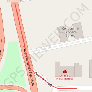
Name: Teste trail, distance, elevation, map, profile, GPS track
Coordinates: -9.65093 -35.73336 -9.65008 -35.73273
Thank you for supporting this site ❤️
Make a donation
Make a donation
Gear up for your next adventure:
As an Amazon Associate, this site earns from qualifying purchases at no extra cost to you.