Make a donation
Gear up for your next adventure:
As an Amazon Associate, this site earns from qualifying purchases at no extra cost to you.
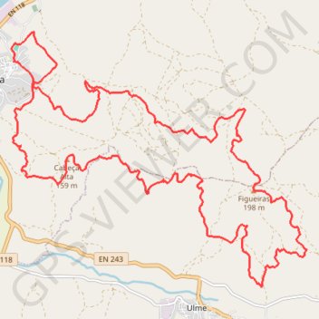
Chamusca Corrida
- Distance: 18.9 mi
- Elevation gain: 3,379 ft
- Maximum elevation: 653 ft
- Elevation loss: 3,376 ft
- Minimum elevation: 157 ft
- Moving time: 18 h 34 m
- Moving speed: 1.0 mph
- Maximum speed: 18.2 mph
- Total time: 1 d 6 h
- Global speed: 0.6 mph
Interactive trail map
Make a donation
Gear up for your next adventure:
As an Amazon Associate, this site earns from qualifying purchases at no extra cost to you.
Trail profile
- Distance: 18.9 mi
- Elevation gain: 3,379 ft
- Maximum elevation: 653 ft
- Elevation loss: 3,376 ft
- Minimum elevation: 157 ft
- Moving time: 18 h 34 m
- Moving speed: 1.0 mph
- Maximum speed: 18.2 mph
- Total time: 1 d 6 h
- Global speed: 0.6 mph
Make a donation
Gear up for your next adventure:
As an Amazon Associate, this site earns from qualifying purchases at no extra cost to you.
About this trail
Name: Chamusca Corrida trail, distance, elevation, map, profile, GPS track
Start: Rua da Chã, Chamusca e Pinheiro Grande, Chamusca, Santarém, 2140-083, Portugal (39.35917 -8.47266)
Coordinates: 39.31886 -8.47316 39.36455 -8.40510
Make a donation
Gear up for your next adventure:
As an Amazon Associate, this site earns from qualifying purchases at no extra cost to you.
Other hiking, mountain biking, running and outdoor activity trails
Click on a trail to view its statistics, map and profile.
Camino Portugues Central
Portugal > Lisbon > Lisbon > Madalena
Lissabon - Porto: 347 km<br> Porto - Santiago: 242 km<br><br><a href="https://www.santiago.nl/product-categorie/gidsen/gidsen-portugal/">Gids</a><br>
Distance: 375.5 mi • Elevation gain: 27,198 ft • Maximum elevation: 1,542 ft
EuroVelo 1 (Por
Portugal > Viana do Castelo > Caminha > Terreiro
Distance: 718.6 mi • Elevation gain: 35,509 ft • Maximum elevation: 833 ft
Southern section — European Divide Trail
France > Auvergne-Rhône-Alpes > Drôme > Valence
Distance: 1,506.1 mi • Elevation gain: 139,026 ft • Maximum elevation: 6,578 ft