Thank you for supporting this site ❤️
Make a donation
Make a donation
Gear up for your next adventure:
As an Amazon Associate, this site earns from qualifying purchases at no extra cost to you.
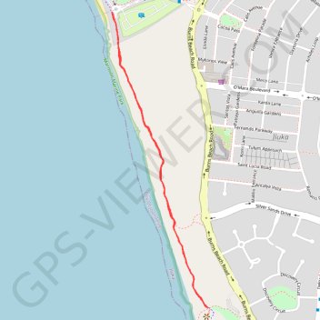
Burns Beach
- Distance: 1.7 mi
- Elevation gain: 98 ft
- Maximum elevation: 59 ft
- Elevation loss: 98 ft
- Minimum elevation: 10 ft
Interactive trail map
Thank you for supporting this site ❤️
Make a donation
Make a donation
Gear up for your next adventure:
As an Amazon Associate, this site earns from qualifying purchases at no extra cost to you.
Trail profile
- Distance: 1.7 mi
- Elevation gain: 98 ft
- Maximum elevation: 59 ft
- Elevation loss: 98 ft
- Minimum elevation: 10 ft
Thank you for supporting this site ❤️
Make a donation
Make a donation
Gear up for your next adventure:
As an Amazon Associate, this site earns from qualifying purchases at no extra cost to you.
About this trail
Name: Burns Beach trail, distance, elevation, map, profile, GPS track
Start: Burns Beach PSP, Iluka, City of Joondalup, Western Australia, 6028, Australia (-31.73103 115.71927)
End: Burns Beach PSP, Iluka, City of Joondalup, Western Australia, 6028, Australia (-31.73103 115.71927)
Coordinates: -31.74187 115.71919 -31.73075 115.72344
Thank you for supporting this site ❤️
Make a donation
Make a donation
Gear up for your next adventure:
As an Amazon Associate, this site earns from qualifying purchases at no extra cost to you.
Other hiking, mountain biking, running and outdoor activity trails
Click on a trail to view its statistics, map and profile.