Thank you for supporting this site ❤️
Make a donation
Make a donation
Gear up for your next adventure:
As an Amazon Associate, this site earns from qualifying purchases at no extra cost to you.
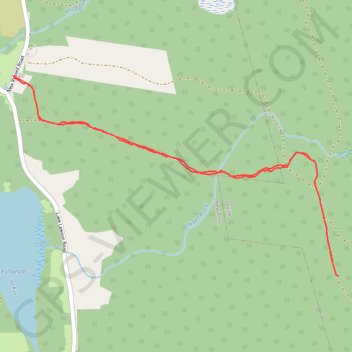
Popner Hill Trail
- Distance: 3.9 mi
- Elevation gain: 371 ft
- Maximum elevation: 719 ft
- Elevation loss: 371 ft
- Minimum elevation: 358 ft
- Moving time: 1 h 26 m
- Moving speed: 2.7 mph
- Maximum speed: 5.1 mph
- Total time: 1 h 38 m
- Global speed: 2.4 mph
Interactive trail map
Thank you for supporting this site ❤️
Make a donation
Make a donation
Gear up for your next adventure:
As an Amazon Associate, this site earns from qualifying purchases at no extra cost to you.
Trail profile
- Distance: 3.9 mi
- Elevation gain: 371 ft
- Maximum elevation: 719 ft
- Elevation loss: 371 ft
- Minimum elevation: 358 ft
- Moving time: 1 h 26 m
- Moving speed: 2.7 mph
- Maximum speed: 5.1 mph
- Total time: 1 h 38 m
- Global speed: 2.4 mph
Thank you for supporting this site ❤️
Make a donation
Make a donation
Gear up for your next adventure:
As an Amazon Associate, this site earns from qualifying purchases at no extra cost to you.
About this trail
Name: Popner Hill Trail trail, distance, elevation, map, profile, GPS track
Coordinates: 44.72479 -64.45041 44.73640 -64.42386
Thank you for supporting this site ❤️
Make a donation
Make a donation
Gear up for your next adventure:
As an Amazon Associate, this site earns from qualifying purchases at no extra cost to you.