Make a donation
Gear up for your next adventure:
As an Amazon Associate, this site earns from qualifying purchases at no extra cost to you.
Corona and Bowtie Arches
Interactive trail map
Make a donation
Gear up for your next adventure:
As an Amazon Associate, this site earns from qualifying purchases at no extra cost to you.
Trail profile
- Distance: 2.4 mi
- Elevation gain: 702 ft
- Maximum elevation: 4,442 ft
- Elevation loss: 702 ft
- Minimum elevation: 3,983 ft
Make a donation
Gear up for your next adventure:
As an Amazon Associate, this site earns from qualifying purchases at no extra cost to you.
About this trail
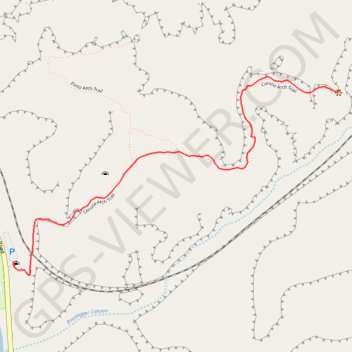
Name: Corona and Bowtie Arches trail, distance, elevation, map, profile, GPS track
Start: Corona Arch Trailhead, Potash Road, Grand County, Utah, United States (38.57449 -109.63243)
End: Corona Arch Trailhead, Corona Arch Trail, Grand County, Utah, United States (38.57450 -109.63243)
Coordinates: 38.57405 -109.63243 38.58050 -109.61892
Topography: Grand County topographic map, elevation, terrain
Make a donation
Gear up for your next adventure:
As an Amazon Associate, this site earns from qualifying purchases at no extra cost to you.
Other hiking, mountain biking, running and outdoor activity trails
Click on a trail to view its statistics, map and profile.
Corona Arch Trail
United States > Utah > Grand County
The Corona Arch Trail near Moab offers a captivating journey through the rugged desert landscape. Hikers pass by two other notable arches, Pinto Arch and Bowtie Arch, before reaching the grand Corona Arch. Along the way, sections of slickrock, metal cables, and even a small ladder add a bit of adventure,…
Distance: 2.6 mi • Elevation gain: 745 ft • Maximum elevation: 4,452 ft