Make a donation
Gear up for your next adventure:
As an Amazon Associate, this site earns from qualifying purchases at no extra cost to you.
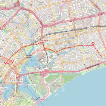
Marina Parade -> Haji Lane
- Distance: 5.8 mi
- Elevation gain: 154 ft
- Maximum elevation: 62 ft
- Elevation loss: 161 ft
- Minimum elevation: 20 ft
Interactive trail map
Make a donation
Gear up for your next adventure:
As an Amazon Associate, this site earns from qualifying purchases at no extra cost to you.
Trail profile
- Distance: 5.8 mi
- Elevation gain: 154 ft
- Maximum elevation: 62 ft
- Elevation loss: 161 ft
- Minimum elevation: 20 ft
Make a donation
Gear up for your next adventure:
As an Amazon Associate, this site earns from qualifying purchases at no extra cost to you.
About this trail
Name: Marina Parade -> Haji Lane trail, distance, elevation, map, profile, GPS track
End: 61, Bussorah Street, Rochor, Central, Singapore, 199471, Singapore (1.30160 103.85962)
Coordinates: 1.29984 103.85464 1.31141 103.90691
Make a donation
Gear up for your next adventure:
As an Amazon Associate, this site earns from qualifying purchases at no extra cost to you.
Other hiking, mountain biking, running and outdoor activity trails
Click on a trail to view its statistics, map and profile.
Singapore East Coast Park
Distance: 7.8 mi • Elevation gain: 259 ft • Maximum elevation: 72 ft
Directions from Duck Tour Ramp to Marina Boulevard, Singapore
Distance: 65.5 mi • Elevation gain: 2,664 ft • Maximum elevation: 167 ft
Morning Run
Distance: 8.4 mi • Elevation gain: 545 ft • Maximum elevation: 69 ft
Make a donation
Gear up for your next adventure:
As an Amazon Associate, this site earns from qualifying purchases at no extra cost to you.