Thank you for supporting this site ❤️
Make a donation
Make a donation
Gear up for your next adventure:
As an Amazon Associate, this site earns from qualifying purchases at no extra cost to you.
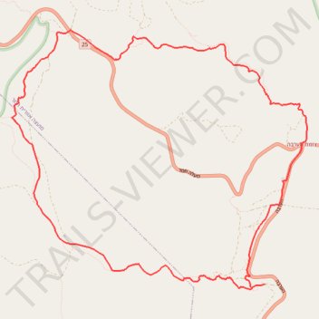
Tzafit and Paras
צפית ופרס: קצר בין שני נחלים יפיופים בצפון הערבה
- Distance: 9.8 mi
- Elevation gain: 1,375 ft
- Maximum elevation: 207 ft
- Elevation loss: 1,375 ft
- Minimum elevation: -797 ft
- Moving time: 4 h 27 m
- Moving speed: 2.2 mph
- Maximum speed: 2.8 mph
- Total time: 4 h 27 m
- Global speed: 2.2 mph
Interactive trail map
Thank you for supporting this site ❤️
Make a donation
Make a donation
Gear up for your next adventure:
As an Amazon Associate, this site earns from qualifying purchases at no extra cost to you.
Trail profile
- Distance: 9.8 mi
- Elevation gain: 1,375 ft
- Maximum elevation: 207 ft
- Elevation loss: 1,375 ft
- Minimum elevation: -797 ft
- Moving time: 4 h 27 m
- Moving speed: 2.2 mph
- Maximum speed: 2.8 mph
- Total time: 4 h 27 m
- Global speed: 2.2 mph
Thank you for supporting this site ❤️
Make a donation
Make a donation
Gear up for your next adventure:
As an Amazon Associate, this site earns from qualifying purchases at no extra cost to you.
About this trail
Name: Tzafit and Paras trail, distance, elevation, map, profile, GPS track
Start: HaArava, Tamar Regional Council, Beersheba Subdistrict, South District, Israel (30.97133 35.30452)
End: HaArava, Tamar Regional Council, Beersheba Subdistrict, South District, Israel (30.97133 35.30452)
Coordinates: 30.97062 35.26564 31.00488 35.31108
Thank you for supporting this site ❤️
Make a donation
Make a donation
Gear up for your next adventure:
As an Amazon Associate, this site earns from qualifying purchases at no extra cost to you.