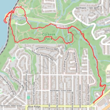
Thank you for supporting this site ❤️
Make a donation
Make a donation
Gear up for your next adventure:
As an Amazon Associate, this site earns from qualifying purchases at no extra cost to you.
Carkeek Park trails
- Distance: 3.8 mi
- Elevation gain: 476 ft
- Maximum elevation: 243 ft
- Elevation loss: 476 ft
- Minimum elevation: 0 ft
- Moving time: 2 h 42 m
- Moving speed: 1.4 mph
- Maximum speed: 6.1 mph
- Total time: 3 h 16 m
- Global speed: 1.2 mph
Interactive trail map
Thank you for supporting this site ❤️
Make a donation
Make a donation
Gear up for your next adventure:
As an Amazon Associate, this site earns from qualifying purchases at no extra cost to you.
Trail profile
- Distance: 3.8 mi
- Elevation gain: 476 ft
- Maximum elevation: 243 ft
- Elevation loss: 476 ft
- Minimum elevation: 0 ft
- Moving time: 2 h 42 m
- Moving speed: 1.4 mph
- Maximum speed: 6.1 mph
- Total time: 3 h 16 m
- Global speed: 1.2 mph
Thank you for supporting this site ❤️
Make a donation
Make a donation
Gear up for your next adventure:
As an Amazon Associate, this site earns from qualifying purchases at no extra cost to you.
About this trail
Name: Carkeek Park trails trail, distance, elevation, map, profile, GPS track
Coordinates: 47.70177 -122.38062 47.71319 -122.36297
Topography: Seattle topographic map, elevation, terrain
Thank you for supporting this site ❤️
Make a donation
Make a donation
Gear up for your next adventure:
As an Amazon Associate, this site earns from qualifying purchases at no extra cost to you.