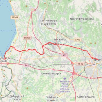
2022_DE_Peschiera-Verona
- Distance: 21.1 mi
- Elevation gain: 912 ft
- Maximum elevation: 623 ft
- Elevation loss: 922 ft
- Minimum elevation: 197 ft
Interactive trail map
Trail profile
- Distance: 21.1 mi
- Elevation gain: 912 ft
- Maximum elevation: 623 ft
- Elevation loss: 922 ft
- Minimum elevation: 197 ft
About this trail
Name: 2022_DE_Peschiera-Verona trail, distance, elevation, map, profile, GPS track
Start: Piazzale Cesare Betteloni, Peschiera del Garda, Verona, Veneto, 37019, Italy (45.43917 10.69212)
End: Via degli Alpini, San Zeno, Centro Storico, Verona, Veneto, 37122, Italy (45.43830 10.99195)
Coordinates: 45.43830 10.69212 45.47694 10.99195
Other hiking, mountain biking, running and outdoor activity trails
Click on a trail to view its statistics, map and profile.
2022_DE_Verona-Vicenza | flach
Italy > Veneto > Verona > Verona
Distance: 45.5 mi • Elevation gain: 1,545 ft • Maximum elevation: 522 ft