Thank you for supporting this site ❤️
Make a donation
Make a donation
Gear up for your next adventure:
As an Amazon Associate, this site earns from qualifying purchases at no extra cost to you.
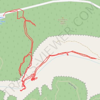
Gooseberry-springs-little-plain
- Distance: 2.0 mi
- Elevation gain: 427 ft
- Maximum elevation: 5,164 ft
- Elevation loss: 423 ft
- Minimum elevation: 4,839 ft
- Moving time: 1 h 3 m
- Moving speed: 1.9 mph
- Maximum speed: 3.3 mph
- Total time: 3 h 42 m
- Global speed: 0.5 mph
Interactive trail map
Thank you for supporting this site ❤️
Make a donation
Make a donation
Gear up for your next adventure:
As an Amazon Associate, this site earns from qualifying purchases at no extra cost to you.
Trail profile
- Distance: 2.0 mi
- Elevation gain: 427 ft
- Maximum elevation: 5,164 ft
- Elevation loss: 423 ft
- Minimum elevation: 4,839 ft
- Moving time: 1 h 3 m
- Moving speed: 1.9 mph
- Maximum speed: 3.3 mph
- Total time: 3 h 42 m
- Global speed: 0.5 mph
Thank you for supporting this site ❤️
Make a donation
Make a donation
Gear up for your next adventure:
As an Amazon Associate, this site earns from qualifying purchases at no extra cost to you.
About this trail
Name: Gooseberry-springs-little-plain trail, distance, elevation, map, profile, GPS track
Start: Apple Valley, Washington County, Utah, United States (37.14196 -113.17090)
Coordinates: 37.13789 -113.17122 37.14209 -113.16528
Topography: Washington County topographic map, elevation, terrain
Thank you for supporting this site ❤️
Make a donation
Make a donation
Gear up for your next adventure:
As an Amazon Associate, this site earns from qualifying purchases at no extra cost to you.