Thank you for supporting this site ❤️
Make a donation
Make a donation
Gear up for your next adventure:
As an Amazon Associate, this site earns from qualifying purchases at no extra cost to you.
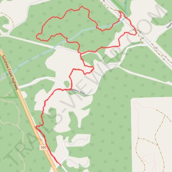
Homesite Creek Loop Walk
- Distance: 4.1 mi
- Elevation gain: 525 ft
- Maximum elevation: 574 ft
- Elevation loss: 522 ft
- Minimum elevation: 240 ft
- Moving time: 1 h 58 m
- Moving speed: 2.1 mph
- Maximum speed: 3.8 mph
- Total time: 2 h 44 m
- Global speed: 1.5 mph
Interactive trail map
Thank you for supporting this site ❤️
Make a donation
Make a donation
Gear up for your next adventure:
As an Amazon Associate, this site earns from qualifying purchases at no extra cost to you.
Trail profile
- Distance: 4.1 mi
- Elevation gain: 525 ft
- Maximum elevation: 574 ft
- Elevation loss: 522 ft
- Minimum elevation: 240 ft
- Moving time: 1 h 58 m
- Moving speed: 2.1 mph
- Maximum speed: 3.8 mph
- Total time: 2 h 44 m
- Global speed: 1.5 mph
Thank you for supporting this site ❤️
Make a donation
Make a donation
Gear up for your next adventure:
As an Amazon Associate, this site earns from qualifying purchases at no extra cost to you.
About this trail
Name: Homesite Creek Loop Walk trail, distance, elevation, map, profile, GPS track
Coordinates: 49.52494 -123.92827 49.53868 -123.91496
Thank you for supporting this site ❤️
Make a donation
Make a donation
Gear up for your next adventure:
As an Amazon Associate, this site earns from qualifying purchases at no extra cost to you.