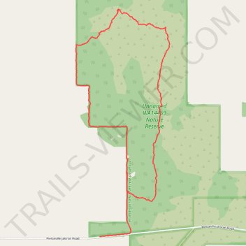
Thank you for supporting this site ❤️
Make a donation
Make a donation
Gear up for your next adventure:
As an Amazon Associate, this site earns from qualifying purchases at no extra cost to you.
Jaloran
- Distance: 4.3 mi
- Elevation gain: 236 ft
- Maximum elevation: 1,273 ft
- Elevation loss: 246 ft
- Minimum elevation: 1,132 ft
- Moving time: 1 h 44 m
- Moving speed: 2.5 mph
- Maximum speed: 17.3 mph
- Total time: 3 h 7 m
- Global speed: 1.4 mph
Interactive trail map
Thank you for supporting this site ❤️
Make a donation
Make a donation
Gear up for your next adventure:
As an Amazon Associate, this site earns from qualifying purchases at no extra cost to you.
Trail profile
- Distance: 4.3 mi
- Elevation gain: 236 ft
- Maximum elevation: 1,273 ft
- Elevation loss: 246 ft
- Minimum elevation: 1,132 ft
- Moving time: 1 h 44 m
- Moving speed: 2.5 mph
- Maximum speed: 17.3 mph
- Total time: 3 h 7 m
- Global speed: 1.4 mph
Thank you for supporting this site ❤️
Make a donation
Make a donation
Gear up for your next adventure:
As an Amazon Associate, this site earns from qualifying purchases at no extra cost to you.
About this trail
Name: Jaloran trail, distance, elevation, map, profile, GPS track
Coordinates: -33.16620 117.35987 -33.14437 117.37063
Thank you for supporting this site ❤️
Make a donation
Make a donation
Gear up for your next adventure:
As an Amazon Associate, this site earns from qualifying purchases at no extra cost to you.