Make a donation
Gear up for your next adventure:
As an Amazon Associate, this site earns from qualifying purchases at no extra cost to you.
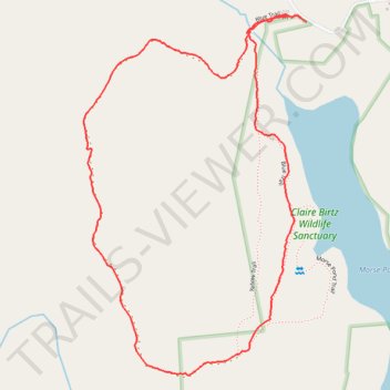
Walking the Blue and Red trails at Claire Birtz Wildlife Sanctuary
- Distance: 1.9 mi
- Elevation gain: 243 ft
- Maximum elevation: 682 ft
- Elevation loss: 240 ft
- Minimum elevation: 525 ft
- Moving time: 54 m
- Moving speed: 2.1 mph
- Maximum speed: 4.4 mph
- Total time: 59 m 7 s
- Global speed: 1.9 mph
Interactive trail map
Make a donation
Gear up for your next adventure:
As an Amazon Associate, this site earns from qualifying purchases at no extra cost to you.
Trail profile
- Distance: 1.9 mi
- Elevation gain: 243 ft
- Maximum elevation: 682 ft
- Elevation loss: 240 ft
- Minimum elevation: 525 ft
- Moving time: 54 m
- Moving speed: 2.1 mph
- Maximum speed: 4.4 mph
- Total time: 59 m 7 s
- Global speed: 1.9 mph
Make a donation
Gear up for your next adventure:
As an Amazon Associate, this site earns from qualifying purchases at no extra cost to you.
About this trail
Name: Walking the Blue and Red trails at Claire Birtz Wildlife Sanctuary trail, distance, elevation, map, profile, GPS track
Coordinates: 42.02880 -72.02327 42.03758 -72.01599
Topography: Southbridge topographic map, elevation, terrain
Make a donation
Gear up for your next adventure:
As an Amazon Associate, this site earns from qualifying purchases at no extra cost to you.
Other hiking, mountain biking, running and outdoor activity trails
Click on a trail to view its statistics, map and profile.
Loop walk at Claire Birtz Wildlife Sanctuary
United States > Massachusetts > Worcester County > Southbridge
Distance: 1.8 mi • Elevation gain: 213 ft • Maximum elevation: 630 ft