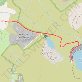
Marchlyn Mawr
- Distance: 1.9 mi
- Elevation gain: 961 ft
- Maximum elevation: 2,106 ft
- Elevation loss: 0 ft
- Minimum elevation: 1,142 ft
- Moving time: 44 m 22 s
- Moving speed: 2.6 mph
- Maximum speed: 3.9 mph
- Total time: 49 m 12 s
- Global speed: 2.4 mph
Interactive trail map
Trail profile
- Distance: 1.9 mi
- Elevation gain: 961 ft
- Maximum elevation: 2,106 ft
- Elevation loss: 0 ft
- Minimum elevation: 1,142 ft
- Moving time: 44 m 22 s
- Moving speed: 2.6 mph
- Maximum speed: 3.9 mph
- Total time: 49 m 12 s
- Global speed: 2.4 mph
About this trail
Name: Marchlyn Mawr trail, distance, elevation, map, profile, GPS track
Start: Llanddeiniolen, Dinorwig, Gwynedd, Wales, LL55 3NA, United Kingdom (53.14666 -4.10169)
End: Llanddeiniolen, Dinorwig, Gwynedd, Wales, LL57 4DJ, United Kingdom (53.13693 -4.07354)
Coordinates: 53.13693 -4.10169 53.14666 -4.07100
Other hiking, mountain biking, running and outdoor activity trails
Click on a trail to view its statistics, map and profile.
Ultra-Trail Snowdonia Eryri UTS 100M
United Kingdom > Wales > Gwynedd > Llanberis
Distance: 101.4 mi • Elevation gain: 31,837 ft • Maximum elevation: 3,471 ft