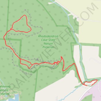
Rhododendron Cove Trails
- Distance: 2.3 mi
- Elevation gain: 387 ft
- Maximum elevation: 1,050 ft
- Elevation loss: 390 ft
- Minimum elevation: 768 ft
- Moving time: 57 m 49 s
- Moving speed: 2.3 mph
- Maximum speed: 22.9 mph
- Total time: 1 h 30 m
- Global speed: 1.5 mph
Interactive trail map
Trail profile
- Distance: 2.3 mi
- Elevation gain: 387 ft
- Maximum elevation: 1,050 ft
- Elevation loss: 390 ft
- Minimum elevation: 768 ft
- Moving time: 57 m 49 s
- Moving speed: 2.3 mph
- Maximum speed: 22.9 mph
- Total time: 1 h 30 m
- Global speed: 1.5 mph
About this trail
Name: Rhododendron Cove Trails trail, distance, elevation, map, profile, GPS track
Coordinates: 39.63161 -82.56791 39.63736 -82.55802
Topography: Fairfield County topographic map, elevation, terrain
Other hiking, mountain biking, running and outdoor activity trails
Click on a trail to view its statistics, map and profile.