Make a donation
Gear up for your next adventure:
As an Amazon Associate, this site earns from qualifying purchases at no extra cost to you.
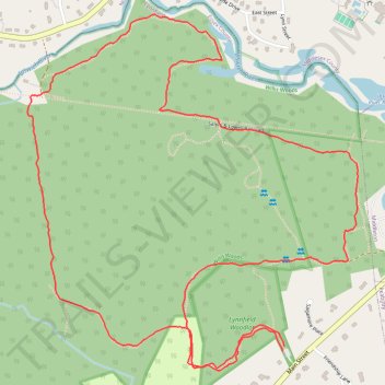
Lynnfield Woodlot and Willis Woods loop
- Distance: 3.2 mi
- Elevation gain: 148 ft
- Maximum elevation: 164 ft
- Elevation loss: 148 ft
- Minimum elevation: 59 ft
- Moving time: 1 h 8 m
- Moving speed: 2.8 mph
- Maximum speed: 6.2 mph
- Total time: 1 h 14 m
- Global speed: 2.6 mph
Interactive trail map
Make a donation
Gear up for your next adventure:
As an Amazon Associate, this site earns from qualifying purchases at no extra cost to you.
Trail profile
- Distance: 3.2 mi
- Elevation gain: 148 ft
- Maximum elevation: 164 ft
- Elevation loss: 148 ft
- Minimum elevation: 59 ft
- Moving time: 1 h 8 m
- Moving speed: 2.8 mph
- Maximum speed: 6.2 mph
- Total time: 1 h 14 m
- Global speed: 2.6 mph
Make a donation
Gear up for your next adventure:
As an Amazon Associate, this site earns from qualifying purchases at no extra cost to you.
About this trail
Name: Lynnfield Woodlot and Willis Woods loop trail, distance, elevation, map, profile, GPS track
Start: Lynnfield Woodlot, Lynnfield, Essex County, Massachusetts, 01949, United States (42.56362 -71.03835)
End: Lynnfield Woodlot, Lynnfield, Essex County, Massachusetts, 01949, United States (42.56347 -71.03842)
Coordinates: 42.56292 -71.04836 42.57314 -71.03548
Topography: Essex County topographic map, elevation, terrain
Make a donation
Gear up for your next adventure:
As an Amazon Associate, this site earns from qualifying purchases at no extra cost to you.