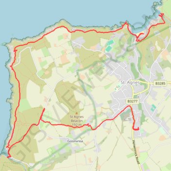
St Agnes
- Distance: 7.1 mi
- Elevation gain: 1,873 ft
- Maximum elevation: 472 ft
- Elevation loss: 1,575 ft
- Minimum elevation: 3 ft
- Moving time: 3 h 28 m
- Moving speed: 2.0 mph
- Maximum speed: 7.3 mph
- Total time: 4 h 32 m
- Global speed: 1.6 mph
Interactive trail map
Trail profile
- Distance: 7.1 mi
- Elevation gain: 1,873 ft
- Maximum elevation: 472 ft
- Elevation loss: 1,575 ft
- Minimum elevation: 3 ft
- Moving time: 3 h 28 m
- Moving speed: 2.0 mph
- Maximum speed: 7.3 mph
- Total time: 4 h 32 m
- Global speed: 1.6 mph
About this trail
Name: St Agnes trail, distance, elevation, map, profile, GPS track
End: Penwinnick Road, St. Agnes, Cornwall, England, TR5 0LA, United Kingdom (50.30576 -5.20278)
Coordinates: 50.30002 -5.23512 50.32343 -5.19500
Other hiking, mountain biking, running and outdoor activity trails
Click on a trail to view its statistics, map and profile.
St Agnes Beacon & Wheal Coates
United Kingdom > England > Cornwall > St. Agnes > Goonvrea
Distance: 2.4 mi • Elevation gain: 171 ft • Maximum elevation: 348 ft
Portreath Oorthtowan Loop
United Kingdom > England > Cornwall > Portreath
Portreath, Oorthtowan
Distance: 14.1 mi • Elevation gain: 2,795 ft • Maximum elevation: 338 ft
Portreath to Porthtowan
United Kingdom > England > Cornwall > Portreath
Distance: 14.7 mi • Elevation gain: 3,091 ft • Maximum elevation: 341 ft
Around Perranporth
United Kingdom > England > Cornwall > Perranzabuloe
Distance: 14.4 mi • Elevation gain: 2,844 ft • Maximum elevation: 335 ft
Perranporth
United Kingdom > England > Cornwall > Goonhavern > Rosehill
Distance: 8.8 mi • Elevation gain: 1,867 ft • Maximum elevation: 318 ft