Make a donation
Gear up for your next adventure:
As an Amazon Associate, this site earns from qualifying purchases at no extra cost to you.
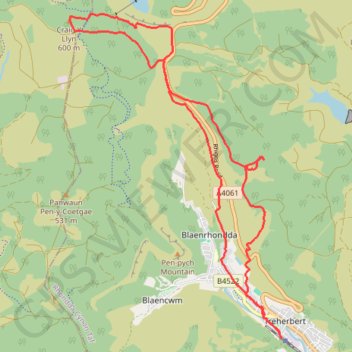
Craig Y Llyn loop
Lunch Walk
- Distance: 10.5 mi
- Elevation gain: 1,713 ft
- Maximum elevation: 1,978 ft
- Elevation loss: 1,716 ft
- Minimum elevation: 597 ft
- Moving time: 4 h 33 m
- Moving speed: 2.3 mph
- Maximum speed: 6.2 mph
- Total time: 5 h 18 m
- Global speed: 2.0 mph
Interactive trail map
Make a donation
Gear up for your next adventure:
As an Amazon Associate, this site earns from qualifying purchases at no extra cost to you.
Trail profile
- Distance: 10.5 mi
- Elevation gain: 1,713 ft
- Maximum elevation: 1,978 ft
- Elevation loss: 1,716 ft
- Minimum elevation: 597 ft
- Moving time: 4 h 33 m
- Moving speed: 2.3 mph
- Maximum speed: 6.2 mph
- Total time: 5 h 18 m
- Global speed: 2.0 mph
Make a donation
Gear up for your next adventure:
As an Amazon Associate, this site earns from qualifying purchases at no extra cost to you.
About this trail
Name: Craig Y Llyn loop trail, distance, elevation, map, profile, GPS track
Start: Station Terrace, Treherbert, Rhondda Cynon Taf, Wales, CF42 5HU, United Kingdom (51.67194 -3.53583)
End: Station Terrace, Treherbert, Rhondda Cynon Taf, Wales, CF42 5HU, United Kingdom (51.67188 -3.53559)
Coordinates: 51.67188 -3.58371 51.71751 -3.53559
Make a donation
Gear up for your next adventure:
As an Amazon Associate, this site earns from qualifying purchases at no extra cost to you.
Other hiking, mountain biking, running and outdoor activity trails
Click on a trail to view its statistics, map and profile.
The Headstock 500
United Kingdom > Wales > Newport > Newport
Distance: 300.4 mi • Elevation gain: 31,549 ft • Maximum elevation: 2,267 ft
Treorchy, Cearphilly, Pen y Fan
United Kingdom > Wales > Caerphilly County Borough > Tredegar
Distance: 79.1 mi • Elevation gain: 6,345 ft • Maximum elevation: 1,644 ft