Thank you for supporting this site ❤️
Make a donation
Make a donation
Gear up for your next adventure:
As an Amazon Associate, this site earns from qualifying purchases at no extra cost to you.
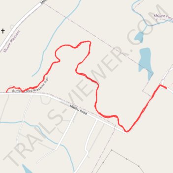
Buffalo Creek Preserve Trail
- Distance: 2.1 mi
- Elevation gain: 148 ft
- Maximum elevation: 653 ft
- Elevation loss: 154 ft
- Minimum elevation: 558 ft
- Moving time: 55 m
- Moving speed: 2.3 mph
- Maximum speed: 5.7 mph
- Total time: 1 h 16 m
- Global speed: 1.7 mph
Interactive trail map
Thank you for supporting this site ❤️
Make a donation
Make a donation
Gear up for your next adventure:
As an Amazon Associate, this site earns from qualifying purchases at no extra cost to you.
Trail profile
- Distance: 2.1 mi
- Elevation gain: 148 ft
- Maximum elevation: 653 ft
- Elevation loss: 154 ft
- Minimum elevation: 558 ft
- Moving time: 55 m
- Moving speed: 2.3 mph
- Maximum speed: 5.7 mph
- Total time: 1 h 16 m
- Global speed: 1.7 mph
Thank you for supporting this site ❤️
Make a donation
Make a donation
Gear up for your next adventure:
As an Amazon Associate, this site earns from qualifying purchases at no extra cost to you.
About this trail
Name: Buffalo Creek Preserve Trail trail, distance, elevation, map, profile, GPS track
Coordinates: 35.37740 -80.44456 35.38186 -80.43491
Topography: Cabarrus County topographic map, elevation, terrain
Thank you for supporting this site ❤️
Make a donation
Make a donation
Gear up for your next adventure:
As an Amazon Associate, this site earns from qualifying purchases at no extra cost to you.