Make a donation
Gear up for your next adventure:
As an Amazon Associate, this site earns from qualifying purchases at no extra cost to you.
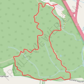
Grassy Ridge Trail and Mountain Trail Loop
- Distance: 3.2 mi
- Elevation gain: 466 ft
- Maximum elevation: 1,260 ft
- Elevation loss: 472 ft
- Minimum elevation: 981 ft
- Moving time: 1 h 15 m
- Moving speed: 2.5 mph
- Maximum speed: 5.9 mph
- Total time: 1 h 26 m
- Global speed: 2.2 mph
Interactive trail map
Make a donation
Gear up for your next adventure:
As an Amazon Associate, this site earns from qualifying purchases at no extra cost to you.
Trail profile
- Distance: 3.2 mi
- Elevation gain: 466 ft
- Maximum elevation: 1,260 ft
- Elevation loss: 472 ft
- Minimum elevation: 981 ft
- Moving time: 1 h 15 m
- Moving speed: 2.5 mph
- Maximum speed: 5.9 mph
- Total time: 1 h 26 m
- Global speed: 2.2 mph
Make a donation
Gear up for your next adventure:
As an Amazon Associate, this site earns from qualifying purchases at no extra cost to you.
About this trail
Name: Grassy Ridge Trail and Mountain Trail Loop trail, distance, elevation, map, profile, GPS track
Start: Grassy Ridge Trail, Surry County, North Carolina, 27043, United States (36.34072 -80.46021)
End: Grassy Ridge Trail, Surry County, North Carolina, 27043, United States (36.34044 -80.46113)
Coordinates: 36.32851 -80.46896 36.34090 -80.45767
Topography: Surry County topographic map, elevation, terrain
Make a donation
Gear up for your next adventure:
As an Amazon Associate, this site earns from qualifying purchases at no extra cost to you.