Thank you for supporting this site ❤️
Make a donation
Make a donation
Gear up for your next adventure:
As an Amazon Associate, this site earns from qualifying purchases at no extra cost to you.
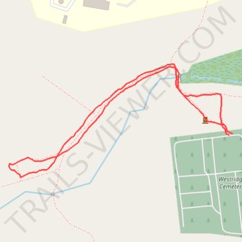
Short walk on Overlook trails near Westridge Cemetery
- Distance: 0.7 mi
- Elevation gain: 75 ft
- Maximum elevation: 853 ft
- Elevation loss: 82 ft
- Minimum elevation: 794 ft
- Moving time: 21 m 3 s
- Moving speed: 2.0 mph
- Maximum speed: 4.0 mph
- Total time: 23 m 40 s
- Global speed: 1.7 mph
Interactive trail map
Thank you for supporting this site ❤️
Make a donation
Make a donation
Gear up for your next adventure:
As an Amazon Associate, this site earns from qualifying purchases at no extra cost to you.
Trail profile
- Distance: 0.7 mi
- Elevation gain: 75 ft
- Maximum elevation: 853 ft
- Elevation loss: 82 ft
- Minimum elevation: 794 ft
- Moving time: 21 m 3 s
- Moving speed: 2.0 mph
- Maximum speed: 4.0 mph
- Total time: 23 m 40 s
- Global speed: 1.7 mph
Thank you for supporting this site ❤️
Make a donation
Make a donation
Gear up for your next adventure:
As an Amazon Associate, this site earns from qualifying purchases at no extra cost to you.
About this trail
Name: Short walk on Overlook trails near Westridge Cemetery trail, distance, elevation, map, profile, GPS track
Coordinates: 42.13448 -71.97828 42.13625 -71.97358
Topography: Worcester County topographic map, elevation, terrain
Thank you for supporting this site ❤️
Make a donation
Make a donation
Gear up for your next adventure:
As an Amazon Associate, this site earns from qualifying purchases at no extra cost to you.