Thank you for supporting this site ❤️
Make a donation
Make a donation
Gear up for your next adventure:
As an Amazon Associate, this site earns from qualifying purchases at no extra cost to you.
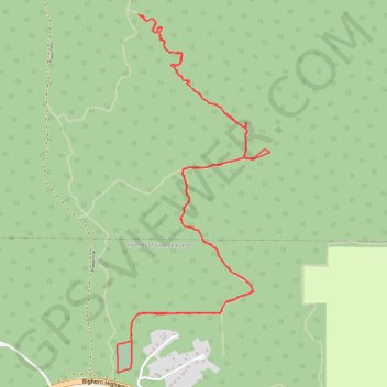
La Petite Grande
Afternoon Trail Run
- Distance: 4.6 mi
- Elevation gain: 1,460 ft
- Maximum elevation: 5,407 ft
- Elevation loss: 1,460 ft
- Minimum elevation: 3,976 ft
- Moving time: 1 h 43 m
- Moving speed: 2.7 mph
- Maximum speed: 6.6 mph
- Total time: 1 h 51 m
- Global speed: 2.5 mph
Interactive trail map
Thank you for supporting this site ❤️
Make a donation
Make a donation
Gear up for your next adventure:
As an Amazon Associate, this site earns from qualifying purchases at no extra cost to you.
Trail profile
- Distance: 4.6 mi
- Elevation gain: 1,460 ft
- Maximum elevation: 5,407 ft
- Elevation loss: 1,460 ft
- Minimum elevation: 3,976 ft
- Moving time: 1 h 43 m
- Moving speed: 2.7 mph
- Maximum speed: 6.6 mph
- Total time: 1 h 51 m
- Global speed: 2.5 mph
Thank you for supporting this site ❤️
Make a donation
Make a donation
Gear up for your next adventure:
As an Amazon Associate, this site earns from qualifying purchases at no extra cost to you.
About this trail
Name: La Petite Grande trail, distance, elevation, map, profile, GPS track
Coordinates: 53.89900 -119.12554 53.91529 -119.11370
Thank you for supporting this site ❤️
Make a donation
Make a donation
Gear up for your next adventure:
As an Amazon Associate, this site earns from qualifying purchases at no extra cost to you.
Other hiking, mountain biking, running and outdoor activity trails
Click on a trail to view its statistics, map and profile.
El Grande Norte Loop
Canada > Alberta > Municipal District of Greenview > Hamlet of Grande Cache
Distance: 3.9 mi • Elevation gain: 1,509 ft • Maximum elevation: 5,417 ft