Make a donation
Gear up for your next adventure:
As an Amazon Associate, this site earns from qualifying purchases at no extra cost to you.
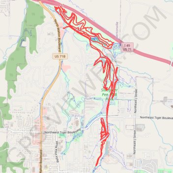
Slaughter Pen MTB Loops
Mountain Bike loops at Slaughter Pen along Town Branch Creek. #MTB #Loop #Forest #River #Nature
- Distance: 17.2 mi
- Elevation gain: 1,647 ft
- Maximum elevation: 1,263 ft
- Elevation loss: 1,647 ft
- Minimum elevation: 1,066 ft
- Moving time: 9 h 59 m
- Moving speed: 1.7 mph
- Maximum speed: 8.0 mph
- Total time: 10 h 57 m
- Global speed: 1.6 mph
Interactive trail map
Make a donation
Gear up for your next adventure:
As an Amazon Associate, this site earns from qualifying purchases at no extra cost to you.
Trail profile
- Distance: 17.2 mi
- Elevation gain: 1,647 ft
- Maximum elevation: 1,263 ft
- Elevation loss: 1,647 ft
- Minimum elevation: 1,066 ft
- Moving time: 9 h 59 m
- Moving speed: 1.7 mph
- Maximum speed: 8.0 mph
- Total time: 10 h 57 m
- Global speed: 1.6 mph
Make a donation
Gear up for your next adventure:
As an Amazon Associate, this site earns from qualifying purchases at no extra cost to you.
About this trail
Name: Slaughter Pen MTB Loops trail, distance, elevation, map, profile, GPS track
Start: Northwest A Street, Bentonville, Benton County, Arkansas, 72712, United States (36.40836 -94.21533)
End: Northwest A Street, Bentonville, Benton County, Arkansas, 72712, United States (36.40833 -94.21530)
Coordinates: 36.37881 -94.21758 36.41298 -94.20058
Topography: Bentonville topographic map, elevation, terrain
Make a donation
Gear up for your next adventure:
As an Amazon Associate, this site earns from qualifying purchases at no extra cost to you.