Tomato Lake Reserve
- Distance: 0.7 mi
- Elevation gain: 10 ft
- Maximum elevation: 62 ft
- Elevation loss: 13 ft
- Minimum elevation: 52 ft
- Moving time: 14 m 41 s
- Moving speed: 2.7 mph
- Maximum speed: 4.6 mph
- Total time: 18 m 34 s
- Global speed: 2.2 mph
Interactive trail map
Trail profile
- Distance: 0.7 mi
- Elevation gain: 10 ft
- Maximum elevation: 62 ft
- Elevation loss: 13 ft
- Minimum elevation: 52 ft
- Moving time: 14 m 41 s
- Moving speed: 2.7 mph
- Maximum speed: 4.6 mph
- Total time: 18 m 34 s
- Global speed: 2.2 mph
About this trail
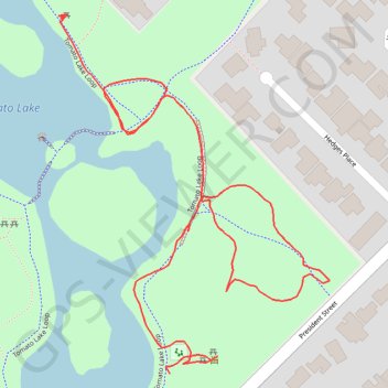
Name: Tomato Lake Reserve trail, distance, elevation, map, profile, GPS track
Start: Tomato Lake Loop, Kewdale, City of Belmont, Western Australia, 6105, Australia (-31.97887 115.93527)
End: Tomato Lake Loop, Kewdale, City of Belmont, Western Australia, 6105, Australia (-31.97623 115.93431)
Coordinates: -31.97887 115.93429 -31.97620 115.93667
Other hiking, mountain biking, running and outdoor activity trails
Click on a trail to view its statistics, map and profile.
Tomato Lake
Australia > Western Australia > City of Belmont
Distance: 0.4 mi • Elevation gain: 10 ft • Maximum elevation: 62 ft