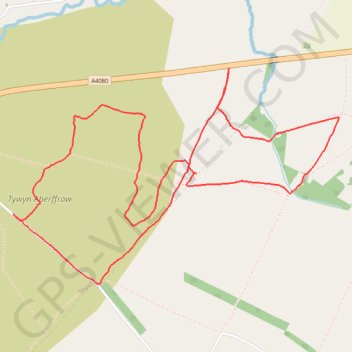
Tywyn Aberffraw
Isle of Anglesey Trail Running
- Distance: 3.8 mi
- Elevation gain: 92 ft
- Maximum elevation: 79 ft
- Elevation loss: 92 ft
- Minimum elevation: 30 ft
- Moving time: 55 m 43 s
- Moving speed: 4.0 mph
- Maximum speed: 6.7 mph
- Total time: 1 h 5 m
- Global speed: 3.5 mph
Interactive trail map
Trail profile
- Distance: 3.8 mi
- Elevation gain: 92 ft
- Maximum elevation: 79 ft
- Elevation loss: 92 ft
- Minimum elevation: 30 ft
- Moving time: 55 m 43 s
- Moving speed: 4.0 mph
- Maximum speed: 6.7 mph
- Total time: 1 h 5 m
- Global speed: 3.5 mph
About this trail
Name: Tywyn Aberffraw trail, distance, elevation, map, profile, GPS track
Start: A4080, Aberffraw, Isle of Anglesey, Wales, LL63 5AX, United Kingdom (53.19509 -4.43910)
End: A4080, Aberffraw, Isle of Anglesey, Wales, LL63 5AX, United Kingdom (53.19505 -4.43910)
Coordinates: 53.18554 -4.45501 53.19509 -4.43098