Unmapped logging road south of Marys river
- Distance: 16.9 mi
- Elevation gain: 2,185 ft
- Maximum elevation: 915 ft
- Elevation loss: 2,195 ft
- Minimum elevation: 364 ft
- Moving time: 1 h 51 m
- Moving speed: 9.2 mph
- Maximum speed: 38.8 mph
- Total time: 1 h 58 m
- Global speed: 8.6 mph
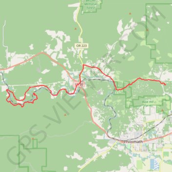
Interactive trail map
Trail profile
- Distance: 16.9 mi
- Elevation gain: 2,185 ft
- Maximum elevation: 915 ft
- Elevation loss: 2,195 ft
- Minimum elevation: 364 ft
- Moving time: 1 h 51 m
- Moving speed: 9.2 mph
- Maximum speed: 38.8 mph
- Total time: 1 h 58 m
- Global speed: 8.6 mph
About this trail
Name: Unmapped logging road south of Marys river trail, distance, elevation, map, profile, GPS track
Start: Harris Road, Harris, Benton County, Oregon, United States (44.57834 -123.48031)
End: 7359, Northwest Acorn Ridge Drive, Benton County, Oregon, 97330, United States (44.58592 -123.33116)
Coordinates: 44.56755 -123.51067 44.60158 -123.33116
Topography: Benton County topographic map, elevation, terrain
Other hiking, mountain biking, running and outdoor activity trails
Click on a trail to view its statistics, map and profile.
Trails and roads around Dunn Forest
United States > Oregon > Benton County
Distance: 27.1 mi • Elevation gain: 4,974 ft • Maximum elevation: 1,873 ft