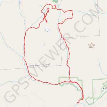
Stony Brook Loop Hike
- Distance: 9.7 mi
- Elevation gain: 1,444 ft
- Maximum elevation: 2,287 ft
- Elevation loss: 1,417 ft
- Minimum elevation: 1,096 ft
- Moving time: 4 h 50 m
- Moving speed: 2.0 mph
- Maximum speed: 5.0 mph
- Total time: 6 h 30 m
- Global speed: 1.5 mph
Interactive trail map
Trail profile
- Distance: 9.7 mi
- Elevation gain: 1,444 ft
- Maximum elevation: 2,287 ft
- Elevation loss: 1,417 ft
- Minimum elevation: 1,096 ft
- Moving time: 4 h 50 m
- Moving speed: 2.0 mph
- Maximum speed: 5.0 mph
- Total time: 6 h 30 m
- Global speed: 1.5 mph
About this trail
Name: Stony Brook Loop Hike trail, distance, elevation, map, profile, GPS track
Coordinates: 41.46661 -76.18703 41.50149 -76.15901
Topography: Forkston Township topographic map, elevation, terrain
Other hiking, mountain biking, running and outdoor activity trails
Click on a trail to view its statistics, map and profile.
Candyland Rock Maze Bald
United States > Pennsylvania > Wyoming County > Forkston Township
Rock Maze Loop Hike
Distance: 9.4 mi • Elevation gain: 1,352 ft • Maximum elevation: 2,274 ft
Flat Top Vista Hike
United States > Pennsylvania > Wyoming County > North Branch Township
Distance: 5.2 mi • Elevation gain: 335 ft • Maximum elevation: 2,215 ft