Make a donation
Gear up for your next adventure:
As an Amazon Associate, this site earns from qualifying purchases at no extra cost to you.
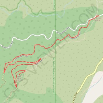
Sunset Peak
Hike from Cow Canyon Saddle to Sunset Peak by the Sunset Ridge Fire Road in the San Gabriel Mountains National Monument and the Angeles National Forest. #Hiking #Mountain #Forest #Nature #Angeles
- Distance: 3.6 mi
- Elevation gain: 1,722 ft
- Maximum elevation: 5,774 ft
- Elevation loss: 499 ft
- Minimum elevation: 4,528 ft
Interactive trail map
Make a donation
Gear up for your next adventure:
As an Amazon Associate, this site earns from qualifying purchases at no extra cost to you.
Trail profile
- Distance: 3.6 mi
- Elevation gain: 1,722 ft
- Maximum elevation: 5,774 ft
- Elevation loss: 499 ft
- Minimum elevation: 4,528 ft
Make a donation
Gear up for your next adventure:
As an Amazon Associate, this site earns from qualifying purchases at no extra cost to you.
About this trail
Name: Sunset Peak trail, distance, elevation, map, profile, GPS track
End: Sunset Ridge Fire Road, Los Angeles County, California, United States (34.21644 -117.68939)
Coordinates: 34.21405 -117.69301 34.22810 -117.67043
Topography: Los Angeles County topographic map, elevation, terrain
Make a donation
Gear up for your next adventure:
As an Amazon Associate, this site earns from qualifying purchases at no extra cost to you.