Thank you for supporting this site ❤️
Make a donation
Make a donation
Gear up for your next adventure:
As an Amazon Associate, this site earns from qualifying purchases at no extra cost to you.
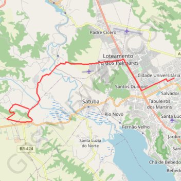
Utinga
- Distance: 16.5 mi
- Elevation gain: 702 ft
- Maximum elevation: 387 ft
- Elevation loss: 919 ft
- Minimum elevation: 7 ft
- Moving time: 6 h 48 m
- Moving speed: 2.4 mph
- Maximum speed: 2.6 mph
- Total time: 6 h 48 m
- Global speed: 2.4 mph
Interactive trail map
Thank you for supporting this site ❤️
Make a donation
Make a donation
Gear up for your next adventure:
As an Amazon Associate, this site earns from qualifying purchases at no extra cost to you.
Trail profile
- Distance: 16.5 mi
- Elevation gain: 702 ft
- Maximum elevation: 387 ft
- Elevation loss: 919 ft
- Minimum elevation: 7 ft
- Moving time: 6 h 48 m
- Moving speed: 2.4 mph
- Maximum speed: 2.6 mph
- Total time: 6 h 48 m
- Global speed: 2.4 mph
Thank you for supporting this site ❤️
Make a donation
Make a donation
Gear up for your next adventure:
As an Amazon Associate, this site earns from qualifying purchases at no extra cost to you.
About this trail
Name: Utinga trail, distance, elevation, map, profile, GPS track
Coordinates: -9.58647 -35.89336 -9.53424 -35.75228
Thank you for supporting this site ❤️
Make a donation
Make a donation
Gear up for your next adventure:
As an Amazon Associate, this site earns from qualifying purchases at no extra cost to you.