Thank you for supporting this site ❤️
Make a donation
Make a donation
Gear up for your next adventure:
As an Amazon Associate, this site earns from qualifying purchases at no extra cost to you.
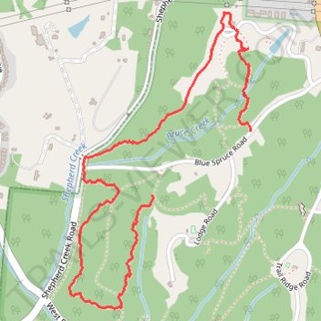
Lingo Trail, E Trail and Arboretum Trail Loop in Mount Airy Forest
- Distance: 2.0 mi
- Elevation gain: 256 ft
- Maximum elevation: 883 ft
- Elevation loss: 197 ft
- Minimum elevation: 728 ft
- Moving time: 1 h 2 m
- Moving speed: 2.0 mph
- Maximum speed: 3.9 mph
- Total time: 1 h 34 m
- Global speed: 1.3 mph
Interactive trail map
Thank you for supporting this site ❤️
Make a donation
Make a donation
Gear up for your next adventure:
As an Amazon Associate, this site earns from qualifying purchases at no extra cost to you.
Trail profile
- Distance: 2.0 mi
- Elevation gain: 256 ft
- Maximum elevation: 883 ft
- Elevation loss: 197 ft
- Minimum elevation: 728 ft
- Moving time: 1 h 2 m
- Moving speed: 2.0 mph
- Maximum speed: 3.9 mph
- Total time: 1 h 34 m
- Global speed: 1.3 mph
Thank you for supporting this site ❤️
Make a donation
Make a donation
Gear up for your next adventure:
As an Amazon Associate, this site earns from qualifying purchases at no extra cost to you.
About this trail
Name: Lingo Trail, E Trail and Arboretum Trail Loop in Mount Airy Forest trail, distance, elevation, map, profile, GPS track
Start: Lingo Trail (K), Cincinnati, Hamilton County, Ohio, 45211, United States (39.17538 -84.57525)
Coordinates: 39.17123 -84.57916 39.18208 -84.57062
Topography: Cincinnati topographic map, elevation, terrain
Thank you for supporting this site ❤️
Make a donation
Make a donation
Gear up for your next adventure:
As an Amazon Associate, this site earns from qualifying purchases at no extra cost to you.