Thank you for supporting this site ❤️
Make a donation
Make a donation
Gear up for your next adventure:
As an Amazon Associate, this site earns from qualifying purchases at no extra cost to you.
Miette Hot Spring - Sulphur Mountain
Interactive trail map
Thank you for supporting this site ❤️
Make a donation
Make a donation
Gear up for your next adventure:
As an Amazon Associate, this site earns from qualifying purchases at no extra cost to you.
Trail profile
- Distance: 5.5 mi
- Elevation gain: 2,267 ft
- Maximum elevation: 6,775 ft
- Elevation loss: 2,218 ft
- Minimum elevation: 4,524 ft
Thank you for supporting this site ❤️
Make a donation
Make a donation
Gear up for your next adventure:
As an Amazon Associate, this site earns from qualifying purchases at no extra cost to you.
About this trail
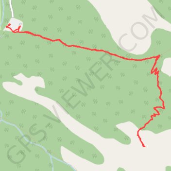
Name: Miette Hot Spring - Sulphur Mountain trail, distance, elevation, map, profile, GPS track
Start: Miette Road, Improvement District No. 12, Alberta, Canada (53.13039 -117.77172)
End: Sulphur Skyline Trail, Improvement District No. 12, Alberta, Canada (53.12948 -117.77105)
Coordinates: 53.11560 -117.77242 53.13039 -117.74070
Thank you for supporting this site ❤️
Make a donation
Make a donation
Gear up for your next adventure:
As an Amazon Associate, this site earns from qualifying purchases at no extra cost to you.