Make a donation
Gear up for your next adventure:
As an Amazon Associate, this site earns from qualifying purchases at no extra cost to you.
Little Wild Horse Canyon Trail in Muddy Creek Wilderness
The Little Wild Horse Canyon Trail offers an unforgettable journey through the rugged terrain of the San Rafael Swell. As you venture into the narrow slot canyon, the towering red rock walls gradually close in, creating an awe-inspiring atmosphere that contrasts with the wide, open desert landscapes at the trail’s beginning. Along the way, hikers encounter sections where they can navigate tight crevices, climb over boulders, and occasionally wade through pools of water, providing both a challenge and a refreshing experience, especially after rain. #Hiking #Nature #Canyon #Desert #Rock
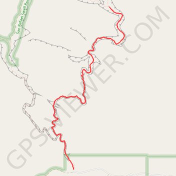
- Distance: 3.6 mi
- Elevation gain: 1,312 ft
- Maximum elevation: 5,535 ft
- Elevation loss: 846 ft
- Minimum elevation: 4,961 ft
Interactive trail map
Make a donation
Gear up for your next adventure:
As an Amazon Associate, this site earns from qualifying purchases at no extra cost to you.
Trail profile
- Distance: 3.6 mi
- Elevation gain: 1,312 ft
- Maximum elevation: 5,535 ft
- Elevation loss: 846 ft
- Minimum elevation: 4,961 ft
Make a donation
Gear up for your next adventure:
As an Amazon Associate, this site earns from qualifying purchases at no extra cost to you.
About this trail
Name: Little Wild Horse Canyon Trail in Muddy Creek Wilderness trail, distance, elevation, map, profile, GPS track
Start: Little Wild Horse & Bell Canyon Trail, Emery County, Utah, United States (38.58294 -110.80290)
End: Little Wild Horse Canyon Trail, Emery County, Utah, United States (38.61157 -110.79492)
Coordinates: 38.58294 -110.80778 38.61157 -110.79152
Topography: Emery County topographic map, elevation, terrain
Make a donation
Gear up for your next adventure:
As an Amazon Associate, this site earns from qualifying purchases at no extra cost to you.
Other hiking, mountain biking, running and outdoor activity trails
Click on a trail to view its statistics, map and profile.
Little Wild Horse Canyon and Bell Canyon Loop in Muddy Creek Wilderness
United States > Utah > Emery County
This loop in the San Rafael Swell is a stunning desert hike that showcases the area's unique geological formations. The trail offers an exciting mix of narrow slot canyons, open desert vistas, and colorful rock walls. As you navigate through Little Wild Horse Canyon, you'll encounter smooth, undulating…
Distance: 8.1 mi • Elevation gain: 2,100 ft • Maximum elevation: 5,692 ft