Make a donation
Gear up for your next adventure:
As an Amazon Associate, this site earns from qualifying purchases at no extra cost to you.
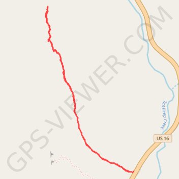
Ten Sleep French Cattle Ranch Approach Long
Washakie County Hiking
- Distance: 2.0 mi
- Elevation gain: 636 ft
- Maximum elevation: 8,005 ft
- Elevation loss: 636 ft
- Minimum elevation: 7,395 ft
- Moving time: 53 m 35 s
- Moving speed: 2.3 mph
- Maximum speed: 3.5 mph
- Total time: 3 h 49 m
- Global speed: 0.5 mph
Interactive trail map
Make a donation
Gear up for your next adventure:
As an Amazon Associate, this site earns from qualifying purchases at no extra cost to you.
Trail profile
- Distance: 2.0 mi
- Elevation gain: 636 ft
- Maximum elevation: 8,005 ft
- Elevation loss: 636 ft
- Minimum elevation: 7,395 ft
- Moving time: 53 m 35 s
- Moving speed: 2.3 mph
- Maximum speed: 3.5 mph
- Total time: 3 h 49 m
- Global speed: 0.5 mph
Make a donation
Gear up for your next adventure:
As an Amazon Associate, this site earns from qualifying purchases at no extra cost to you.
About this trail
Name: Ten Sleep French Cattle Ranch Approach Long trail, distance, elevation, map, profile, GPS track
Start: French Cattle Ranch Approach, Washakie County, Wyoming, 80000, United States (44.13555 -107.25011)
End: US 16, Washakie County, Wyoming, United States (44.13559 -107.24994)
Coordinates: 44.13551 -107.25810 44.14654 -107.24993
Topography: Washakie County topographic map, elevation, terrain
Make a donation
Gear up for your next adventure:
As an Amazon Associate, this site earns from qualifying purchases at no extra cost to you.