Make a donation
Gear up for your next adventure:
As an Amazon Associate, this site earns from qualifying purchases at no extra cost to you.
Hillwalk Snowdon Crib Goch
- Distance: 9.7 mi
- Elevation gain: 3,435 ft
- Maximum elevation: 3,481 ft
- Elevation loss: 3,435 ft
- Minimum elevation: 1,181 ft
- Moving time: 4 h 47 m
- Moving speed: 2.0 mph
- Maximum speed: 7.5 mph
- Total time: 5 h 31 m
- Global speed: 1.8 mph
Interactive trail map
Make a donation
Gear up for your next adventure:
As an Amazon Associate, this site earns from qualifying purchases at no extra cost to you.
Trail profile
- Distance: 9.7 mi
- Elevation gain: 3,435 ft
- Maximum elevation: 3,481 ft
- Elevation loss: 3,435 ft
- Minimum elevation: 1,181 ft
- Moving time: 4 h 47 m
- Moving speed: 2.0 mph
- Maximum speed: 7.5 mph
- Total time: 5 h 31 m
- Global speed: 1.8 mph
Make a donation
Gear up for your next adventure:
As an Amazon Associate, this site earns from qualifying purchases at no extra cost to you.
About this trail
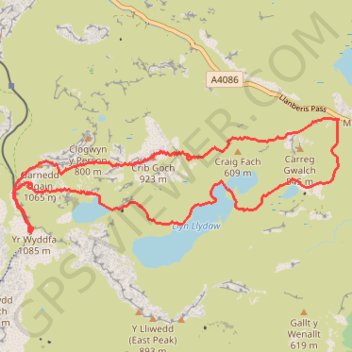
Name: Hillwalk Snowdon Crib Goch trail, distance, elevation, map, profile, GPS track
Start: Pen y Pass, Llanberis Pass, Llanberis, Gwynedd, Wales, LL55 4NU, United Kingdom (53.08042 -4.02093)
End: Pen-y-Pass, Llanberis Pass, Llanberis, Gwynedd, Wales, LL55 4NY, United Kingdom (53.08052 -4.02070)
Coordinates: 53.06797 -4.07992 53.08057 -4.02070
Make a donation
Gear up for your next adventure:
As an Amazon Associate, this site earns from qualifying purchases at no extra cost to you.
Other hiking, mountain biking, running and outdoor activity trails
Click on a trail to view its statistics, map and profile.
Ultra-Trail Snowdonia Eryri UTS 100M
United Kingdom > Wales > Gwynedd > Llanberis
Distance: 101.4 mi • Elevation gain: 31,837 ft • Maximum elevation: 3,471 ft