Wind farm walk
- Distance: 5.7 mi
- Elevation gain: 325 ft
- Maximum elevation: 925 ft
- Elevation loss: 295 ft
- Minimum elevation: 843 ft
- Moving time: 1 h 29 m
- Moving speed: 3.8 mph
- Maximum speed: 38.9 mph
- Total time: 1 h 38 m
- Global speed: 3.5 mph
Interactive trail map
Trail profile
- Distance: 5.7 mi
- Elevation gain: 325 ft
- Maximum elevation: 925 ft
- Elevation loss: 295 ft
- Minimum elevation: 843 ft
- Moving time: 1 h 29 m
- Moving speed: 3.8 mph
- Maximum speed: 38.9 mph
- Total time: 1 h 38 m
- Global speed: 3.5 mph
About this trail
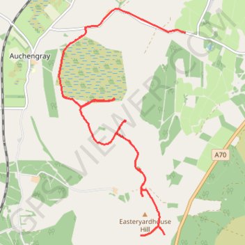
Name: Wind farm walk trail, distance, elevation, map, profile, GPS track
Start: A70, Bertram House, South Lanarkshire, Scotland, ML11 8LG, United Kingdom (55.74415 -3.57368)
End: Polkelly, Auchengray, South Lanarkshire, Scotland, EH55 8LN, United Kingdom (55.77397 -3.56200)
Coordinates: 55.74415 -3.59499 55.77739 -3.56200