Make a donation
Gear up for your next adventure:
As an Amazon Associate, this site earns from qualifying purchases at no extra cost to you.
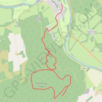
Cardrona Forest - Wallace's Hill
- Distance: 5.7 mi
- Elevation gain: 1,053 ft
- Maximum elevation: 1,516 ft
- Elevation loss: 1,365 ft
- Minimum elevation: 486 ft
- Moving time: 2 h 27 m
- Moving speed: 2.3 mph
- Maximum speed: 4.1 mph
- Total time: 2 h 39 m
- Global speed: 2.1 mph
Interactive trail map
Make a donation
Gear up for your next adventure:
As an Amazon Associate, this site earns from qualifying purchases at no extra cost to you.
Trail profile
- Distance: 5.7 mi
- Elevation gain: 1,053 ft
- Maximum elevation: 1,516 ft
- Elevation loss: 1,365 ft
- Minimum elevation: 486 ft
- Moving time: 2 h 27 m
- Moving speed: 2.3 mph
- Maximum speed: 4.1 mph
- Total time: 2 h 39 m
- Global speed: 2.1 mph
Make a donation
Gear up for your next adventure:
As an Amazon Associate, this site earns from qualifying purchases at no extra cost to you.
About this trail
Name: Cardrona Forest - Wallace's Hill trail, distance, elevation, map, profile, GPS track
Coordinates: 55.61274 -3.11877 55.63918 -3.09890
Make a donation
Gear up for your next adventure:
As an Amazon Associate, this site earns from qualifying purchases at no extra cost to you.
Other hiking, mountain biking, running and outdoor activity trails
Click on a trail to view its statistics, map and profile.
Kailzie Gardens via Drive Wood and River Tweed
United Kingdom > Scotland > Scottish Borders > Cardrona
Distance: 4.1 mi • Elevation gain: 236 ft • Maximum elevation: 604 ft
Cardrona to Glenormiston
United Kingdom > Scotland > Scottish Borders > Cardrona
Distance: 5.0 mi • Elevation gain: 348 ft • Maximum elevation: 712 ft
Cardrona Forest
United Kingdom > Scotland > Scottish Borders > Peebles
Evening Walk
Distance: 4.3 mi • Elevation gain: 653 ft • Maximum elevation: 971 ft