Make a donation
Gear up for your next adventure:
As an Amazon Associate, this site earns from qualifying purchases at no extra cost to you.
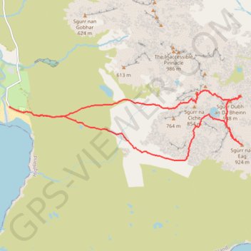
Munro hillwalk Sgurr nan Eag Sgurr Dubh Mor Sgurr Sgumain
Munro, hillwalk, Sgurr, nan, Eag, Dubh, Mor, Sgurr, Sgumain
- Distance: 9.3 mi
- Elevation gain: 4,078 ft
- Maximum elevation: 3,015 ft
- Elevation loss: 4,078 ft
- Minimum elevation: 10 ft
- Moving time: 6 h 17 m
- Moving speed: 1.5 mph
- Maximum speed: 4.9 mph
- Total time: 10 h 15 m
- Global speed: 0.9 mph
Interactive trail map
Make a donation
Gear up for your next adventure:
As an Amazon Associate, this site earns from qualifying purchases at no extra cost to you.
Trail profile
- Distance: 9.3 mi
- Elevation gain: 4,078 ft
- Maximum elevation: 3,015 ft
- Elevation loss: 4,078 ft
- Minimum elevation: 10 ft
- Moving time: 6 h 17 m
- Moving speed: 1.5 mph
- Maximum speed: 4.9 mph
- Total time: 10 h 15 m
- Global speed: 0.9 mph
Make a donation
Gear up for your next adventure:
As an Amazon Associate, this site earns from qualifying purchases at no extra cost to you.
About this trail
Name: Munro hillwalk Sgurr nan Eag Sgurr Dubh Mor Sgurr Sgumain trail, distance, elevation, map, profile, GPS track
Start: Glen Brittle, Highland, Scotland, IV47 8TA, United Kingdom (57.20285 -6.29141)
End: Glen Brittle, Highland, Scotland, IV47 8TA, United Kingdom (57.20287 -6.29134)
Coordinates: 57.19281 -6.29141 57.20592 -6.21119
Make a donation
Gear up for your next adventure:
As an Amazon Associate, this site earns from qualifying purchases at no extra cost to you.