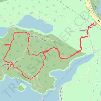
Long Lake Wilderness loop trail
- Distance: 1.7 mi
- Elevation gain: 125 ft
- Maximum elevation: 272 ft
- Elevation loss: 125 ft
- Minimum elevation: 213 ft
- Moving time: 45 m 4 s
- Moving speed: 2.2 mph
- Maximum speed: 3.2 mph
- Total time: 46 m 22 s
- Global speed: 2.2 mph
Interactive trail map
Trail profile
- Distance: 1.7 mi
- Elevation gain: 125 ft
- Maximum elevation: 272 ft
- Elevation loss: 125 ft
- Minimum elevation: 213 ft
- Moving time: 45 m 4 s
- Moving speed: 2.2 mph
- Maximum speed: 3.2 mph
- Total time: 46 m 22 s
- Global speed: 2.2 mph
About this trail
Name: Long Lake Wilderness loop trail trail, distance, elevation, map, profile, GPS track
Coordinates: 44.62893 -63.64602 44.63270 -63.63745
Other hiking, mountain biking, running and outdoor activity trails
Click on a trail to view its statistics, map and profile.
Long Lake Wilderness Loop Trail
Canada > Nova Scotia > Halifax County > Halifax
Distance: 3.1 mi • Elevation gain: 240 ft • Maximum elevation: 259 ft
Long Lake Wilderness Loop
Canada > Nova Scotia > Halifax County > Halifax
Distance: 2.4 mi • Elevation gain: 174 ft • Maximum elevation: 259 ft