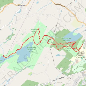
Middletown Reservoir Trails
- Distance: 9.0 mi
- Elevation gain: 732 ft
- Maximum elevation: 906 ft
- Elevation loss: 732 ft
- Minimum elevation: 650 ft
- Moving time: 2 h 31 m
- Moving speed: 3.6 mph
- Maximum speed: 14.8 mph
- Total time: 6 h 36 m
- Global speed: 1.4 mph
Interactive trail map
Trail profile
- Distance: 9.0 mi
- Elevation gain: 732 ft
- Maximum elevation: 906 ft
- Elevation loss: 732 ft
- Minimum elevation: 650 ft
- Moving time: 2 h 31 m
- Moving speed: 3.6 mph
- Maximum speed: 14.8 mph
- Total time: 6 h 36 m
- Global speed: 1.4 mph
About this trail
Name: Middletown Reservoir Trails trail, distance, elevation, map, profile, GPS track
Coordinates: 41.44961 -74.49374 41.46245 -74.44771
Topography: Orange County topographic map, elevation, terrain