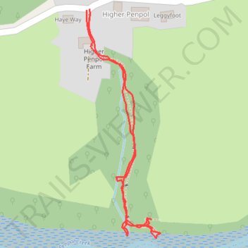
Footpath down to creek from Higher Penpol
- Distance: 0.5 mi
- Elevation gain: 112 ft
- Maximum elevation: 144 ft
- Elevation loss: 112 ft
- Minimum elevation: 33 ft
- Moving time: 21 m 21 s
- Moving speed: 1.5 mph
- Maximum speed: 6.2 mph
- Total time: 29 m 6 s
- Global speed: 1.1 mph
Interactive trail map
Trail profile
- Distance: 0.5 mi
- Elevation gain: 112 ft
- Maximum elevation: 144 ft
- Elevation loss: 112 ft
- Minimum elevation: 33 ft
- Moving time: 21 m 21 s
- Moving speed: 1.5 mph
- Maximum speed: 6.2 mph
- Total time: 29 m 6 s
- Global speed: 1.1 mph
About this trail
Name: Footpath down to creek from Higher Penpol trail, distance, elevation, map, profile, GPS track
Start: Higher Penpol, St. Veep, Golant, Cornwall, England, PL22 0PB, United Kingdom (50.36067 -4.61592)
End: Higher Penpol, St. Veep, Golant, Cornwall, England, PL22 0PB, United Kingdom (50.36068 -4.61587)
Coordinates: 50.35797 -4.61592 50.36068 -4.61455